01 — The corridor
A 20-kilometre arterial between two employment belts
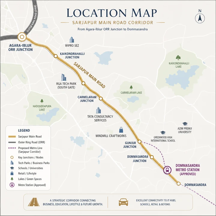
Sarjapur Main Road runs from the Agara–Iblur–Bellandur junction on the Outer Ring Road out to Dommasandra and Sarjapur town. It is among Bengaluru's highest-absorption residential corridors, and the reason is structural rather than fashionable.
The corridor sits between two of the city's largest employment concentrations — the Outer Ring Road belt at its head, and the Whitefield–Electronic City axis to its east and south. A household living on Sarjapur Road can reach a very large share of Bengaluru's technology employment without crossing the city centre. Few corridors offer that.
Layered on top is mature social infrastructure, particularly international schools, which is what converts a commuter corridor into a family one. Sarjapur has had that for over a decade, and it is the reason absorption here has held through multiple market cycles rather than tracking a single employer's fortunes.
02 — Road connectivity
The arterial, the ring roads and what actually improves
| Route | Detail |
|---|---|
| Sarjapur Main Road | 20 km arterial, Outer Ring Road (Agara–Iblur–Bellandur) to Dommasandra and Sarjapur town |
| Outer Ring Road | Head of the corridor |
| Hosur Road / NH-44 | Access south toward Electronic City |
| Varthur Road | Connection north-east toward Whitefield |
| Satellite Town Ring Road (NH-948A) | 280.8 km ring road passing the Sarjapur area; several stretches operational as of 2024, full completion expected 2029 |
| Peripheral Ring Road | 74 km planned, Tumkur Road to Hosur Road |
The Satellite Town Ring Road is the more consequential of the two ring roads for this corridor. As stretches open, regional and long-distance traffic — logistics in particular — moves off the arterials, which is the mechanism by which Sarjapur Main Road's congestion actually improves. Full completion in 2029 lands close to this project's likely possession window, which is one of the few pieces of infrastructure timing that genuinely aligns with a purchase here.
03 — Metro
Namma Metro Phase 3A — the accurate position
This deserves precision, because Sarjapur marketing routinely overstates it and the corridor's case is strong enough without inflation.
The alignment runs elevated from Sarjapur to Koramangala 3rd Block across 15 stations, then underground from Koramangala 3rd Block to the Veterinary College across 11 stations, with further elevated stations at Gangannagar and Hebbal. Approved stations on the Sarjapur end include Sarjapur, Kada Agrahara Road, Dommasandra, Carmelram and Bellandur Gate.
The honest read: this is a real, state-approved, fully-planned corridor with a confirmed station near the site. It is also roughly a decade from carrying passengers. Buy this location for its road connectivity and employment access today, and treat the metro as long-horizon upside — meaningful for a fifteen-year hold, largely irrelevant for a five-year one. Any marketing that implies the metro is imminent should be discounted.
| Field | Status |
|---|---|
| Corridor | Hebbal – Sarjapur |
| Length | 37 km |
| Stations | 28 |
| Budget | ₹28,405 crore |
| Dommasandra station | Approved and on the alignment |
| State Cabinet approval | 6 December 2024 |
| Union Cabinet approval | Pending — expected by end-2026 |
| Construction tender | Not issued as of Q1 2026 |
| Expected construction start | 2027–28 |
| Targeted completion | 2032–33 |
04 — Employment
Four employment concentrations, not one
| Destination | Time / distance |
|---|---|
| RGA Tech Park | 15–25 minutes |
| Pritech Park | 15–25 minutes |
| Sarjapur Road IT cluster | 15–25 minutes |
| Wipro Sarjapur campus | 25–35 minutes |
| RMZ Ecospace, Bellandur | 25–35 minutes |
| Embassy Tech Village | 25–35 minutes |
| Electronic City via Hosur Road | ~16 km |
| Whitefield via Sarjapur and Bellandur | ~17 km · 60–90 min peak |
The spread matters more than any single figure. Sarjapur Road is not dependent on one tech park — it serves the Outer Ring Road belt, the Sarjapur cluster, Electronic City and Whitefield. A two-career household can have one person working at Embassy Tech Village and the other at Electronic City without either commute being unreasonable. Corridors tied to a single employment node do not offer that resilience, and it shows up in vacancy rates when a large employer restructures.
The Whitefield figure is the one to be realistic about: 17 kilometres, but 60 to 90 minutes at peak. Whitefield is reachable from Sarjapur Road. It is not conveniently reachable daily, and anyone whose office is there should test the run before treating the distance as the relevant number.
05 — Social infrastructure
Schools, healthcare and everyday retail
Schools
International schooling is the corridor's strongest social asset, and the acquisition release calls it out explicitly. Greenwood High International, Indus International at Billapura, Inventure Academy on the Whitefield–Sarjapur stretch, Harvest International, The International School Bangalore, Oakridge International, Silver Oaks International, Primus Public School and Gear Innovative International at Doddakannelli all sit on or beside this corridor, along with Azim Premji University.
This concentration is unusual even by Bengaluru standards and is the single most common reason families choose Sarjapur Road over comparably priced corridors. For a household with school-age children it frequently decides the purchase outright, before layout or amenity enter the conversation.
Healthcare
Manipal Hospital and Columbia Asia anchor tertiary care on the corridor itself, with Motherhood Hospital and an Apollo Clinic alongside. Sakra World Hospital at Bellandur and Cloudnine are reachable via the Outer Ring Road, and the Koramangala cluster including St. John's Medical College Hospital sits beyond that.
Retail and everyday life
Sarjapur Road's retail is strip-format rather than mall-dominated for most of its length — a dense ribbon of supermarkets, restaurants, cafes and services along the arterial, with organised malls concentrated at the Outer Ring Road end. Market Square Mall and Total Mall sit on the corridor; Central Mall at Bellandur and Nexus Koramangala are the larger-format options, and Decathlon is on the arterial itself.
For daily life this works well: you are rarely more than a few minutes from a supermarket, a pharmacy or a restaurant. For mall-format shopping the trip is toward Bellandur or Koramangala, which at peak hour is a genuine outing rather than an errand.
When the exact site is disclosed: drive the commute from the actual parcel at 9 a.m. and 7 p.m. on a weekday; establish which stretch the parcel sits on and check the prevailing rate for that stretch rather than the corridor average; ask about water source, sanctioned borewells, storage and BWSSB status; check the approach-road width and condition from the arterial; ask what adjoins the parcel and what is sanctioned on it; and verify the Dommasandra station distance from the actual site rather than from the corridor.
06 — Trade-offs
The honest weaknesses of this corridor
Traffic is the defining weakness. Sarjapur Main Road carries substantially more vehicles than its width supports. Peak-hour movement toward the Outer Ring Road or Whitefield is slow and unpredictable. This is not a marginal complaint — it is the reason some buyers choose other corridors, and it should be tested by driving the route at 9 a.m. and 7 p.m. before buying anything here.
The metro is a decade away. State-approved, Union approval pending, no tender issued, completion targeted 2032–33. It will transform the corridor. It will not do so soon.
Supply is heavy. Sarjapur Road is one of Bengaluru's most actively developed corridors, with a large volume of launched and under-construction inventory. Expect competition at resale and in the rental market, and price your exit assumptions accordingly.
Water is a genuine question. Much of Sarjapur Road sits outside comprehensive Cauvery supply and depends on borewells and tankers. Ask specifically about the project's water source, sanctioned borewell provision, storage capacity and whether a BWSSB connection is expected.
Infrastructure lags development. Drainage, road widening and civic services have consistently trailed residential build-out. The ring-road and metro projects will help, on their own timelines rather than yours.
The pricing note worth flagging
The acquisition release positions this site near Dommasandra, where the stretch rate is ₹7,500–₹9,500 per sq.ft. The developer's own gross development value arithmetic implies ₹11,000–₹12,000 — main-corridor pricing. Either the parcel sits closer to the Outer Ring Road end than "near Dommasandra" suggests, or Shriram is pricing at a premium to its immediate stretch on the strength of the metro station and a premium high-rise product. Both are legitimate, and both make establishing the exact parcel location the single most important pre-purchase step on this project.
Questions
Shriram Sarjapur Road location FAQs
Where the parcel sits, what is genuinely reachable, and what the metro timeline actually says rather than what corridor marketing implies.
Where exactly on Sarjapur Main Road is the site?
The exact parcel has not been publicly disclosed. The acquisition release cites connectivity to Sarjapur, Varthur, Whitefield and the Outer Ring Road, and proximity to reputed international schools and the upcoming Dommasandra Metro Station, which places it toward the Dommasandra side of the corridor. Establishing the precise location is the most important step before committing money, because the Dommasandra stretch trades well below the main-corridor average.
Which employment centres are actually reachable?
RGA Tech Park, Pritech Park and the Sarjapur Road IT cluster are 15 to 25 minutes away. Wipro Sarjapur, RMZ Ecospace and Embassy Tech Village are 25 to 35 minutes. Electronic City is about 16 km via Hosur Road and Whitefield about 17 km via Sarjapur and Bellandur, although Whitefield takes 60 to 90 minutes at peak. The spread matters more than any single figure — a two-career household can work at two different nodes without either commute being unreasonable.
Is Namma Metro Phase 3A actually confirmed for Sarjapur Road?
Yes, at state level. Phase 3A is the 37 km, 28-station Hebbal–Sarjapur corridor budgeted at ₹28,405 crore, and Dommasandra is an approved station on the alignment. The Karnataka State Cabinet approved it on 6 December 2024 and Union Cabinet approval is pending, expected by end-2026. No construction tender had been issued as of Q1 2026, construction is expected around 2027–28, and completion is targeted for 2032–33.
How bad is the traffic on Sarjapur Main Road?
It is the corridor's defining weakness. Sarjapur Main Road carries substantially more vehicles than its width supports, and peak-hour movement toward the Outer Ring Road or Whitefield is slow and unpredictable. Drive your actual commute at 9 a.m. and 7 p.m. on a weekday before deciding — the distance figures and the time figures on this corridor are very different numbers.
What schools are near the corridor?
Sarjapur Road has the highest international-school density of any Bengaluru residential corridor: Greenwood High International, Indus International, Inventure Academy, Harvest International, The International School Bangalore, Oakridge International, Silver Oaks International, Primus Public School and Gear Innovative International, plus Azim Premji University. That concentration is the single most common reason families choose this corridor over comparably priced alternatives.
Ask where Shriram Sarjapur Road actually sits
The exact parcel has not been disclosed, and it is the most important open item on this project. Register interest and we will confirm the location, the stretch rate and the K-RERA registration as soon as Shriram Properties publishes them.